Sep 28, 2009
'Analysis of Neighborhoods"
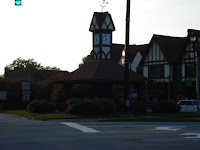
This is one of the "entrance"s of Peachtree Lofts (on Peachtree Street).
"Any neighborhood which is in the direct path of a lower grade area is in danger of being blighted, especially if both areas are served by the same transportation line. The presence of inharmonious racial or national groups in a nearby area also represents a force which may lead to neighborhood decline. Usually the coming in of a lower income group or types of people who will not harmonize with the present occupants in the area results in great instability". (The principles of Urban Real Estate, 1939).
I do not agree with what the author argues, however, the "result" is living behind the bars.
Urban Row Houses
Avondale Estates: A Master Planned New City
Sea Glass Chronicles
Sep 27, 2009
Reynoldstown - Modern Community Planning - The Interwar Period
The Minimum House was marketed as an adaptation in living in response to the modern social conditions and means of production in an industrial economy. Similar to the Pacific Ready-cut Home, this 2 bedroom, living room, kitchen is of basic cinderblock construction and austere design.
Standard, low-cost, minimum houses were designed to be affordable to the average wage earner during the Interwar Period.
Row of 4 Slither houses, facing south. Each house is detached, one room across and has a front porch and yard space on all sides.
Close up views of the homes show that although they were identical in style and design at the time they were built, owners have individualized the structures
Representing the owners personality, these 4 dwellings have been tranformed from standard minimum houses into urban homestead.
2 family shotgun style, mininum houses, located at the southern boundary of Reynoldstown.
Reynoldstown is an Atlanta neighborhood that is nestled between the Cabbagetown and Edgewood communities. Downtown Atlanta is in close proximity to the Reynoldstown Historic District, as it is just two miles west of the district. The district was a strategic position during the Battle of Atlanta in 1864, as its rolling hills and elevation made it one of the highest points in the city. Today, many streets in Reynoldstown bear the names of military leaders who fought in the battle, like Manigault and Wylie. The district’s northern and southern boundaries followed the old Atlanta and West Point Railroad and joined the Central of Georgia (now the CSX) that ran east to west between downtown Atlanta and Decatur.
The Streetcar & Its Involvement in Virginia-Highland
Fig. 1. A large historic house located off the old streetcar path on North Highland.
Kenneth Jackson in Crabgrass Frontier states that no invention “had greater impact on the American city between the Civil War and World War 1 than the visible and noisy streetcar and the tracks that snaked down the broad avenues into undeveloped land (103).” The same is true for the area known as Virginia-Highland. This neighborhood developed as many typical American suburbs did during the early 20th century. It was originally a white, middle-class residential neighborhood with initial growth beginning in 1889 when the Fulton County Street Railroad Company’s Nine-Mile Circle trolley line cut through the area. The streetcar started downtown and traveled along Highland Avenue (now North Highland Avenue), Virginia Avenue, North Boulevard (now Monroe Drive), and back to Highland Avenue before returning to the city. Before the area was developed, Atlanta residents would take the trolley to the “country,” as it was called, to enjoy the cool breezes and relaxing atmosphere.
Fig. 3. Some say that these lines are remnants of the old streetcar that used to run down Virginia. However, I have no proof to confirm or deny this.
Sep 19, 2009
How the Automobile Contributed to Suburbanization
The Painted Laides (San Francisco, CA)
Sep 15, 2009
Concentric Zone Theory Atlanta
Before the great perimeter road of 285, Atlanta displayed concentric zones of business, transition, industry, housing, more expensive housing, rural transitional housing, and finally farmland. Structural artifacts of these past zones can still be seen.
Streetcars then automobiles moved citizens through these zones of housing and employment. Triangles in the street display the gentle curves necessary for streetcars to make turns. These triangles can be seen in many neighborhoods and downtown up to several miles outside the center of Atlanta.
Housing for professionals as described in Zone 4 Residential Zone was connected to the city center by streetcars. The next image also displays Zone 4.
Notice the hybrid car in foreground. This is a sure sign of Zone 4 in 2009.
In 2009 young upwardly mobile professionals enjoy the former streetcar residential areas in Zone 4.
One fine resident with a sporty trike child stroller can be seen in the center of the image.
Zone 2, not far from Zone 4, shows the skeletal remains of industrial production. Fresh human excrement is more common than street trees along the sidewalk in Zone 4. Young professionals enjoy crashing smoky, shady bars in Zone 4 with groups of friends and role playing their parallel life in an urban jungle.
This image of Zone 3 displays the proximity to the central business district. Not pictured, but to right of this image are working class residential housing. The large building in the foreground is government subsidized housing for the elderly.
To be continued.....
Sep 14, 2009
Fragmentation from Berne Ave
Here is an example of industry abandoning the center-city for the fringes. From the overpass oone can see the tops of cranes above the industrial yard and sand dunes. Visible in the background are the towering spires of corporations, proof that Atlanta transitioned to a Corporate City. Gordon suggests capitalist machines are produced to some extent to control the workers. The same can be said for capitalist city growth. What had been advantageous for business (centralized capital in heart of city) turned into an advantage for the working class (centralized capital meant centralized working class and organization of unions).
Businesses at the turn of the 20th century moved to the suburbs in order to smash labor organization by fragmenting (and thereby subduing and controlling) the working class.
Cities that had matured during the industrial (competitive) stage of capitalist development had their downtown shopping districts transformed into business districts as stores and shops too became fragmented and scattered hither and thither.
Cities that came of age in the corporate accumulation (monopoly) stage became "exemplary" Corporate Cities, lodging corporate headquarters downtown and losing tax revenue from the manufacturing plants that were in the city's suburbs. Corporate control of legislatures ensured cities would not annex these areas, thereby furthering the political fragmentation of society.
Visible in the bottom picture are the railroad tracks needed to supply the company (foreground) as well as some the worker housing that developed around the then suburban operation. In the background, visible to the right is the edge of Glenwood Park, a current attempt at gentrification of the neighborhood after businesses in the 20th century left for more farflung suburbs. Glenwood Park itself was built on the site of another company - the Williams Bros. Concrete Company.
Ansley Park: A Motorcar, Pictureque Suburb
Ansley Park is an example of a picturesque, borderland suburb. Though now an Atlanta neighborhood tucked firmly into the Midtown district of Atlanta, when developer Edwin Ansley began Ansley Park in 1904 it was north of the city, which then extended to the Ponce de Leon/North Avenue area. Unlike "streetcar" suburbs developed around railroad transportation, Ansley Park was conceived of as a "motorcar-oriented suburb" of wide, curvilinear streets (similar to Llewellyn Park, NJ), which provided the city's elite/rich businessmen with ample room to park their newfound form of luxury transportation, the automobile. The maze of streets in Ansley Park serves the additional benefit of making the neighborhood difficult to use as a cut-through, increasing its sense of a country-club island, isolated from the lower and middling classes of the polluted cityscape.
Like many picturesque suburbs developed in the late 19th and early 20th centuries, Ansley Park includes an electic mix of architectural styles, as developers as the time focused on landscape architecture, allowing individualization of personal styles, so long as they conformed to minimum zoning standards of the development. Largely finished by 1913 (with all units done by 1930), Ansley Park includes a golf course, two interior park, roads designed as "parkways" (with wide lanes and houses set back from the road), and additionally borders Piedmont Park on the right, the largest park in Midtown Atlanta. Such a development appealed to the idea of "escaping from the dirty city" to a nonetheless close-in place providing privacy and angled views, with much land set aside for leisure.
Ansley Park was once Atlanta's most-elite suburb, being the home of the governor's mansion, before it was supplanted by Buckhead further to the north (the governor's mansion moving to Buckhead in the 1960s). Ansley Park instead has been transformed into a well-maintained neighborhood. The houses range from fairly small starter homes in the $200,000 range to larger mansions up to several million dollars in value. Though restricted in some ways, Ansley Park's boundaries were more social and economic (and racial) than the tangible boundaries of later, gated communities, where iron fences and security guards provided a far more obvious sense of restriction. Yet Ansley Park has, for more than a century, been both a restricted and picturesque suburb.
Kirkwood - A Streetcar Suburb
Kirkwood is an early streetcar suburb of Atlanta established in the 1870s as a residential development. By 1910, Georgia Power and Railway provided affordable streetcar service three times a day between Atlanta and Kirkwood. Kirkwood attracted new residents and maintained itself as an independent municipality with public services such as water and its own local school until it was annexed by the City of Atlanta in 1922.
Located within a block and a half of the streetcar lines (now MARTA), these homes on Murray Hill Avenue were built in a relatively dense, grid-like pattern of narrow lots. Built roughly between 1925 and 1930, the homes on this stretch in Kirkwood also represent the trend of patterned bungalow plans to enable a more economical option for builders and middle-class homeowners. We see only a few basic bungalow patterns with differences in aesthetics such as window framings, siding or trim to represent each home's individuality.